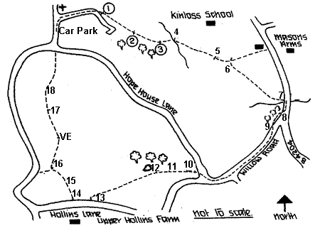
START:
From the church car park, follow the track beside the churchyard wall,
passing the Old Hall, the former Rectory, just below/East of St. Peter's.
This substantial building conceals within its 18th century exterior the
nucleus of a mediaeval hall house with original timbers up to the roof
beams, the hall being divided horizontally in Elizabethan times. Nicholas
Pevsner describes it in his "Buildings of England" series. Continue
along the track to the field gate and diagonally across the field, following
the waymarking signs (1,2). At the end of the rough woodland on the right
the path splits, but this route bears diagonally left at the waymark (3)
to a gate and substantial bridge (4) (replacing an old wooden one, damaged
in floods, June/July 2007) across the Laugherne Brook. Nearby Laugherne
House was enlarged from the original timber farmhouse by a scion of the
Nash family in the C18. The Nashs' of "The Noak" were wealthy
glove makers who removed from Worcester, first to Pudford Grange and then
to the "Noak", and were the local influential family for more
than a century. The house was a school for dyslexic children for some
years prior to its development for housing. Go straight ahead from the
bridge, aiming for a large oak tree, until you see stile (5) and the next
stile (6), in more or less a straight line. Crossing this, a branch to
the left proceeds towards a telephone exchange and the recently (2006)
restored pub, "The Mason's" (formerly The Mason's Arms). Otherwise
head towards the right hand telegraph pole (and distant white house) and
the stile which leads out on to the B4204, again beside the Laugherne
Brook (7). Turn right up the road for some yards where a signpost (8)
indicates the path through scrubby woodland (often very overgrown, and
impossible to traverse) to Willow Road (9), avoiding the road junction
(if the path is overgrown, follow the road round). The boundary of Wichenford
parish runs along this short section. Turn right along Willow Road, noting
the extensive views of Woodbury Hill and the Abberley Hills across to
the right and the Malverns to the left. Continue along Willow Road and
turn right down Hopehouse Lane. Soon a stile and signpost is seen on the
left (10). Climb this and walk ahead through rather marshy ground, keeping
the line of old willows and a pool, built in the late 90's, on your right.
Continue straight ahead to the far corner of the field where a stile (11)
leads into a pasture and, continuing, into the far corner again, cross
a small ditch, over the stile (12) and into field with a large pond frequented
by several varieties of duck. Bear left in front of the pool, to a stile
onto the lane (13). Turn right up the lane until another stile (14) in
the right hedge takes you into another pasture. Keeping the wire fence
on the right, cross a stile (15) into an old (2008--very old, not many
trees left) orchard. Keep alongside the hedge to a stile (16). Here there
is a choice of routes. Bearing left for a short way, a stile leads down
the bank to Hollins Lane which may be followed down to within sight of
the church and car park. Otherwise, cross the stile in the hedge and go
straight ahead, again following a hedge to a seat erected by the Path-or-Nones
to commemmorate VE day, 50 years on. Next cross a stile and short bridge
(17) and look out for the waymarking post at the hedge corner (18) and
go down towards the church and car park. Look to the left for a fine view
of Berrow Hill, upon which stands our local authentic beacon, fired to
commemorate special occasions, as at the quatercentenary of the Spanish
Armada, the advent of the Single European Market, 50th Anniversary of
VE day and of course the New Millennium.