If you like our paths why not join the Path-or-Nones, and meet third Sunday of each month to help maintain them? Its fun, fresh air and free and the only membership fee is a thick skin and a funny hat!
Contact John Pearsall (01886 888793) or John Nicklin (01886 888318) for details or email.
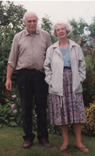
Keith
and Audrey Trumper.
Keith, along with Kevin Oliver of Worcestershire Rights of Way, was instrumental in launching the Path-or-Nones. Keith was known as 'Captain', and much loved by all of us. Audrey has always looked after the group, bringing refreshments to our working parties--thanks Audrey.
Keith, along with Kevin Oliver of Worcestershire Rights of Way, was instrumental in launching the Path-or-Nones. Keith was known as 'Captain', and much loved by all of us. Audrey has always looked after the group, bringing refreshments to our working parties--thanks Audrey.