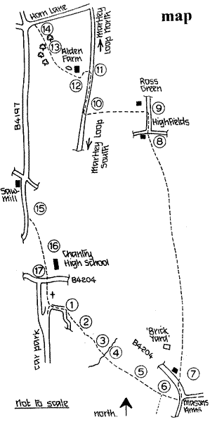
START:
From the church car park, follow the track beside the churchyard wall,
passing the Old Hall, the former Rectory, just below/East of St. Peter's.
This substantial building conceals within its 18th century exterior the
nucleus of a mediaeval hall house with original timbers up to the roof
beams, the hall being divided horizontally in Elizabethan times. Nicholas
Pevsner describes it in his "Buildings of England" series. Continue
along the track to the field gate and diagonally across the field, following
the waymarking signs (1,2). At the end of the rough woodland on the right
the path splits, but this route bears diagonally left at the waymark (3)
to a gate and substantial bridge (4) (replacing an old wooden one, damaged
in floods, June/July 2007) across the Laugherne Brook. Nearby Laugherne
House was enlarged from the original timber farmhouse by a scion of the
Nash family in the C18. The Nashs' of "The Noak" were wealthy
glove makers who removed from Worcester, first to Pudford Grange and then
to the "Noak", and were the local influential family for more
than a century. The house was a school for dyslexic children for some
years prior to its development for housing. Go straight ahead from the
bridge, aiming for a large oak tree, until you see stile (5) and the next
stile (6), in more or less a straight line. Crossing this take the left
branch towards a telephone exchange and the recently (2006) restored pub,
"The Mason's" (formerly The Mason's Arms). Cross the stile and
turn left, alongside the B4204 towards Martley. As the first house on
the right appears, (well set back from the road) look for the signpost
over a stile and into the field via a permissive route (7). Follow the
field edge to a stile in the hedge, cross this and follow the hedgeline.
In this field, adjacent to a pair of cottages, is the site of Martley's
former brickyard, levelled during the Second World War. The brickyard,
which had a clay pit and two kilns, functioned till 1901 when tragedy
befell one of the owners who was fatally burned. Work ceased, and the
brickyard became derelict, before being demolished due to the pressure
for farmland when every ounce of food was needed. From the next stile,
there is a glimpse of Woodbury Hill in the distance, a taste of things
to come. The hedgerow shows ancient blackthorn bushes whose white blossom
is first in spring and, barring late frosts, will bear the sour little
sloes in autumn, to make a delicious sloe gin liqueur. Continue ahead
along the field edge path, crossing a further stile. |
|
| Through
a gap (used to be a pair of stiles) at the end of a field edge coppice,
keep ahead on the field edge path to the next stile and up the field with
fine mature oaks on your right and another stile into a pathway at the
side of the adjacent property (permissive route). This alley has been
attractively planted with primroses and other spring flowers, and small
shrubs, and makes a delightful feature leading to a stile onto the lane
at Highfields (8). Go straight ahead along a short stretch of lane, foaming
with hedge parsley in early summer, and turn left at the signpost (9),
just before the next property.
In
this field, pause and take in the panoramic view sweeping from the Abberley
Hills on the extreme right, across Woodbury Hill and Berrow Hill to the
Malverns, surely one of the finest views in Worcestershire. Continue down
the field following the waymarking signs to cross a secluded brook, watching
out for kingfishers (this crossing can be extremely muddy at times). Bear
slightly left across the field, nearby a utility pole, to a stile in the
fence (10). Turn right along the track to Alden's Farm and sharp left
(11) at the end of the fence in front of the house. In a few yards a stile
(12) leads into a field. Turn at right angles down beside the farmhouse,
pass the large duck pond and over the next stile, again sometimes muddy.
Follow the waymarking sign on this stile to two stiles and a ditch crossing
in the line of trees ahead (13). Bear slightly left to the stile onto
the lane at the junction of the B4197 and Horn Lane (14). Turn left down
the road towards Martley, taking care with the traffic. Pass the small
cross roads nearby the woodyard, climb the hill to the crest, down the
other side and notice a signpost and stile on the left (15). Take this
route, bear diagonally right across the field to a stile, and straight
ahead across the next field to a gap (16) leading into the grounds of
Chantry High School and an avenue of damson trees. At the end the path
veers left onto a track leading down to the main Worcester road (17).
Cross the road carefully and go down the churchyard to the car park and
you start point. |
