| START:
RODGE HILL. Having attained the summit of Rodge Hill, do not turn
right to walk along the ridge, but go down the farm track to Rodge
Hill Farm and continue down to the road. (1) Turn right and in about
60 yards a signpost on the left (2) points the route alongside a
copse which is a mass of bluebells in Spring. At the end of the
field turn right (3) along a farm track to the orchard. Here in
Summer skylarks resound in the blue infinity, their song filling
the air, though they are invisible above. Along the brook, primroses
and violets decorate the banks in Spring. Through the orchard gate
(4), the path leads diagonally left between the trees and continues
to a waymarking post (5). These orchards belong to Bulmers of Hereford
and produce only cider apples. At the post, turn half right along
the low fence, with barns on your left and at the farm gate (6),
turn right down the farm track. At the end, turn left and leave
the orchard via the metal gate (7). Cross the field to the wooden
causeway built over boggy ground (8). Go straight ahead through
the next gate and continue in the same direction to a signpost in
the middle of the field (9). Here the path turns back upon itself
as indicated by the waymarking arrow, and heads towards a gateway
in the hedge (10). |
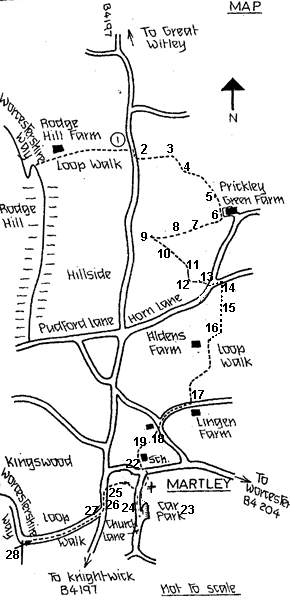 |
Through
the gate, head right across the field to a gate and plank crossing
(11) over a little stream, and in the next field keep along the
hedge on your left to another gate and bridge crossing (12). Go
ahead to a further gate and signpost leading on to the lane (13).
Continue straight ahead, away from Martley towards beautiful Brook
Court. Take the first pedestrian gate (14) to the right (East) and
cross the field to a stile (15); follow the field edge to the corner
then cross the field to a gate (16) onto Alden's Farm drive. Turn
left up the track past Alden's Farm and between pastures to the
junction with Barber's Lane (17) opposite a large farmhouse, Lingen
Farm. Turn right down the lane to a road junction with a tiny grass
triangle in the middle. Take the left hand lane and just after the
bungalow, use the gate on the right (18) and cross this field by
the route usually indicated by stakes and lines, to a gate &
ditch crossing (19). This crossing leads onto the playing field
of the Chantry High School. Turn right up the side of the school
buildings, and walk towards a gap in the hedge. Follow the field
edge to the left, to a gap that leads into an avenue of damson trees,
particularly attractive at blossom time. At the end, the path veers
left then right onto a track leading down to the main Worcester
road (22). Cross the road carefully and go down through the churchyard
by the right hand path to the car park. Follow the waymarking sign
back up the lane, to a signpost and gate on the left (24). Turn
right and follow the fence line to the waymarking arrow by the barn
conversions.Turn left and walk across the field, through a field
gate to gates leading on to the main road (25). Martley has the
'Crown' public house opposite, and the village shop and Post Office
adjacent. If not requiring these amenities, turn left and walk past
the houses and the Memorial Hall (26) to the junction with Kingswood
Lane (27). Crossing carefully, walk up Kingswood Lane to rejoin
the Worcestershire Way at the fingerpost (28). |
|