START:
From the car park at St Peter's Church (1), walk up the churchyard, cross
the B4204 (2) and go up the signed track opposite, bear left through the
avenue of damson trees, through the gap and into the field (3). Go straight
ahead to the stile in the far hedge (4), visible when the crest of the
field is reached. Bear left to the next stile in the roadside hedge (5).
Turn right up the road B4197 to the timber yard and turn left up the lane
by the sawmills (6). At the junction (7) turn left up this rather wet
lane until a sign post appears in the right hand hedge pointing up the
bank (8). Climb this bank with care to emerge on the lower slopes of the
spectacular ridge of Rodge Hill, now (2008) with many more trees, hence
diminished views, than when this pamphlet was written. As you climb, you
can begin to see the unfolding views across the Teme valley, the rolling
contours of the land, with the road to Clifton-on-Teme winding up past
two picturesque timbered houses, and Pitlands farm in its plum orchards.
The view to the right requires patience, somewhat obscured as it is by
a gloomy thicket, paradise for birds, but not to be traversed at a late
hour unless one has strong nerves. Emerging into daylight, go through
the field gate and the grandeur of the Rodge Hill ridge is revealed. Keep
ahead along the summit, noting the gnarled old remnants of hawthorn on
your right, defying the winds that sweep against them straight from Wales.
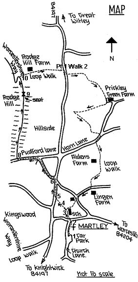
Through the next gateway/ gap continue ahead to the bench (9) placed strategically
by the County Council (in recognition of the work that The Path-or-Nones
do to maintain Martley rights of way), at the best viewpoint from this
high ridge. Below, the River Teme flows between tree lined banks, and
a Norman motte rises gently out of a field near the aptly named Homme
Castle Farm. The nearby Ham Bridge over the Teme replaced, in the nineteenth
century, a ford hidden away downstream at Kingswood on the Worcestershire
Way. The immediate horizon is the Clifton Ridge, punctuated by the spire
of Clifton-on-Teme's church of St. Kenelm, one of only three similar dedications
in the land. Below to the right are Shelsley Beauchamp and its church,
and across the river is Shelsley Walsh, notable for its tiny tufa church
and its famous motor hill climb up the Clifton bank. A light aircraft
runway might also be seen. These views are bounded in the north-west,
by the distant bulk of the Clee Hills, Titterstone Clee with its Iron
Age Hill Fort and radar station, and to its right Brown Clee, higher by
twenty two feet and the highest point in Shropshire. To the south, the
Malverns, and beyond, the Forest of Dean and to the west, maybe a glimpse
of the Black Mountains at Hay Bluff.
Leaving the seat, continue to the junction of paths (10) and turn right onto the Martley Loop Walk, descending past Rodge Hill Farm (no longer a working farm) and down the track, after the barns, veering right along the bridle way to the B4197 (Pt 1 Walk 2). Turn right and from now on the route follows the Martley Loop, described in Walk Two of "Walks in Martley Parish" until the church car park is regained. The Martley Loop is well signposted, passing through orchards and pastures under the lee of Rodge Hill, and is also briefly described in the "Worcestershire Way Map Pamphlet".