START: From St Peter's church carpark, walk south along the road to the three way junction and enter the field opposite the signpost (1). To the right is The Berrow, an outlier of the Malverns, topped by the beacon basket erected for the Armada celebrations in 1988, and ringed by an Iron Age Fort. (This hill has a strange legend attached to it, from the mists of time, which supposes that when the Ancient Britons occupied the Iron Age fort, two chieftains encamped with their followers, Odo on The Berrow and Dodo on Woodbury Hill. In battle Odo was defeated and driven back to Knightwick).
Keep straight on and at the waymarking post go diagonally across the field to a stile and ditch crossing (2). Over the stile, bear left up the field edge path to the commemorative seat, erected in 1995 to celebrate 50 years since vitory in Europe. Looking back, a panoramic view of Martley is revealed, the church in the centre, with the large mansion of Laugherne House (now Laugherne Park) on the right and the equally imposing "Noak" on rising ground to the left. Both these houses once belonged to the wealthy and influential family of Nash, one of whom wrote a comprehensive description of Worcestershire in the 18th century. Continuing up the field, go over the stile at the top into an orchard (3), turn right to another stile and descend the steps onto the lane (4). Turn left up the lane towards Lower-Hollins Farm and right at the signpost before the farmhouse (5). Follow the waymarking signs across the fields (6) to the line of the houses on the main road, under Berrow Hill.
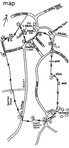
Turn right and after approx. 100 yards cross this road carefully to a sign pointing down a track (7) on your left. At this point we join the Worcestershire Way. Barely a few steps and a metal gate is on the right beside the garden of an attractive cottage. Through this, bear right across the pasture to another gate, noting to the left a pretty timber framed cottage standing alone amid fields. Until recently restored, this was known locally as the "listed henhouse", being a little architectural gem but sadly neglected and given over to poultry and now fortunately rescued. Continue straight to the third gate that leads onto a tarmac driveway. Keep straight on along the tarmac until a waymarking post directs one onto a field edge path to the next post (many follow the tarmac at this point but are not really supposed to). Regain the track, cross over the main drive to Berrow Farm and continue down the field edge with excellent views in front. Berrow Farm is late 17th century, but it is believed that the site has been occupied since the time of Domesday. Keep straight on across the fields, passing a most attractive 'holloway' to the right, until you come to the imposing signpost on the lane (8). At the signpost continue straight on up the hedge line, along the Worcestershire Way, to a gap on the right leading down to Kingswood Lane. Opposite, a signpost points the way through a gate (9). Keep straight ahead to a gate at the top of the rise, on the right. Down below to the left is the hamlet of Kingswood, once an important resting place for travellers crossing the Teme at the ford. Some of the stepping stones can still be seen at low water, and also Millstones, a reminder of the corn mill that stood until around 1900, on the far bank by the ford. Go through the gate and continue, keeping the hedge on your left, to the gap by a marvellous old 'warden' pear tree (10). Walk straight ahead and after approx. 400 yards (and 100 yards before the Clifton Road) turn right (11) and head for the stile which will become visible some way along, at the top of a bank. You are then standing on top of "The Nubbins", the local name for the outcrop of red sandstone which was quarried for centuries, providing stone for the 13th century church and many other buildings. The view over the village and to the Malverns is particularly fine here. Go over the stile (12) and negotiate the steep bank with care to the stile leading into a small copse. Follow the path through the trees to another stile, and continue along the field edge path, past a waymarking post to the road, emerging opposite the Memorial Hall (13). Cross with care, turn left past Jury Lane and Mortlake Drive to a signpost and stile on the right leading to a field (14). Follow the waymarking posts across the field to a gate into Church Lane (15). Turn right down to the car park.