If parking at the "Admiral Rodney Inn" please notify the landlord first. Turn right out of the car park and walk along the road for about 5 minutes and turn right down the lane towards Horsham. Some way down the lne, where a drive goes left, there is a signpost and stile in the hedge.
START From the stile in Horsham Lane go down the field to the sleeper crossing over the marshy ground, keep alongside the willows on the right and go over the ditch crossing and stile (1). Turn left and keeping the hedge on your left, go to the end of the field (ignoring the stile on the left) and cross the stile beyond the wet area (2). Go straight ahead to the waymark which will become visible on the far hedge as you breast the rising ground (3). Follow the direction along the hedge to the next stile (4). Cross the stile and go diagonally across the field to the gate and stile. Turn left towards the farmhouse and go over the ladder stile, keep left and climb another ladder stile (5). Walk to the track and keep on this long track over two more stiles (or through gates) (Notice the old three storeyed timbered building half hidden in trees over to your left. This is believed to have been a courthouse in the 17C & 18C, the circuit judge having his lodgings on the first floor and the local miscreants being kept below awaiting trial. The first floor still shows some good pargetting in the courtroom. The judge would have forded the River Teme on horseback somewhere above Knightwick). In spite of much protest, the owner refuses to restore the property, as is his obligation. It has greatly deteriorated over the last few years. There is a photo survey in the Worcestershire Records Office.
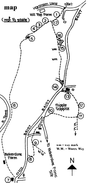
This track eventually goes very near the river (6). In summer large patches of Himalayan balsam clothe the banks with their showy mauve flowers, an unwanted introduction which threatens to swamp other waterloving native species. The track continues through Ankerdine Farm with hop barns and further on, remnant hop fields, examples of a once widely cultivated crop in Worcestershire. Continue to 'The Talbot' (7). Stop and try their famous home brews--'This', 'That', T'other' etc and lunch if you wish, otherwise turn left, now on the Worcestershire Way, up Ankerdine Hill past the (closed) church on the right, the former school on the left and the row of 19th century almshouses, taking great care when the pavement ends. Single file recommended. By the first cottage on the right (8) follow the signpost direction up into the woodland and follow the waymarks up the hill. At a junction (9) the Way turns sharp right and leads up to the Ankerdine Picnic Site and a fine viewpoint. But our way continues straight on to cross the drive of a cottage further up. Continue straight on to another track by a cottage, bear left and walk up to join the main track and continue left. (Picnickers should turn right here the picnic area is about 200 yards further on). Just before the track joins the road, turn right through the kissing gate (10) and go diagonally left down the field to the stile into the woodland of Nipple Coppice. Go down steeply, through the woodland, following the waymarking posts to the junction at the bottom (it can be VERY muddy) and turn left (11). Keep on the path to the gate (12) into the field and turn left up the bank. Go through the gap in the fence and straight up the very steep bank to the small fenced tree at the top (13). Follow the waymark into the farmyard, past the farmhouse along the drive to the road. Turn right and quite soon cross the road with great care to the signpost beside a cottage (14). Go down the track and over the stile by the gate on the right. Keep the hedge on your left down the field and continue down a wooded "holloway". Bear right where the track forks and look for the waymark on the pole. Bear left towards the next waymark on a pole amid bracken (15). Keep straight ahead through the clump of trees and continue straight down the slope keeping to the left of several mature oaks. Further down, a fine 18th century farmhouse will be visible on the high ground in the distance. Head towards this farmhouse, keeping the boundary "hedge" on the left. Over a stile (16) and down the field to a ditch crossing and stile amid the trees (17). Immediately up the bank turn right and go up the field keeping the hedge on your right until a stile is reached which you crossed at the beginning of the walk at point (1). Cross this stile and retrace your steps up to the stile and signpost in Horsham Lane.