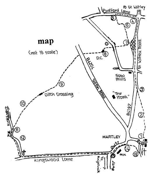
START: From the car park at St. Peter's Church, walk up the churchyard, cross the B4204 and go up the signed track opposite, bear left through the avenue of damson trees, and through the gap (1), thus leaving the school grounds. Go straight ahead to the stile (2) in the far hedge, visible when the crest of the hill is reached. Bear left to the next stile in the roadside hedge (3). Turn right up the road (B4197), taking great care with the speeding traffic, go past the woodyard and lane on the left to the crossroads, turning left into Pudford Lane (4). About 160 yards up the lane cross the stile on the left (5) and walk across the field to the stile at the corner of the hedges (6). Across the stile keep to the left hand hedge to a waymarking post (7) and then turn right to follow the arrow diagonally across the field to a stile leading onto a lane. Turn left and, in a few yards, steps are seen in the right hand hedge. (Further down the lane is what remains of the mediaeval fishpond of "The Noake’, sadly now much overgrown and partially filled in. The remnants of the sluice gate lie beside it in the grass. Presumably the sluice was used to drain water from the pool to make netting the fish easier, when eating fish was compulsory on Fridays, a "fast" day in our Catholic past). Climb the stile and cross the field to the lefthand corner, keeping to the left of the venerable oak tree with its hollow trunk, a hiding place for rabbits. The small copse on the left has been fenced to allow primroses and a few violets to flourish, and later bluebells may appear. Over the stile and ditch crossing (8) in the corner, look for the stile far away across the field leading onto the Clifton road B4204. In fact the path traverses the field itself, and not the field edge, hopefully the farmer will have marked it through the crops. Cross the road to the signpost and gate/stile opposite. Go down the farm track keeping the hedge on your left to the corner of the hedge and waymarking post (9). There are fine views of the River Teme to the right. Descend steeply to a little stream, following an ancient track with a bank to the left, to reach a ditch crossing and climb up the opposite bank. At the top (10) a track leads on (known locally as Chimney Lane--there used to be many small houses and plots hereabouts and apparently a lone chimney stack remained for some time) with rough woodland on the right. Continue along this track to a stile. Keep in the same direction passing after a while an ancient tractor almost buried in bracken and greenery, until a stile onto the road is reached. At this point our route joins the Worcestershire Way (11). Turn left up the (Kingswood) lane. At the top of the hill a few steps in the right hand bank lead to a gap into a field. (An alternative route to Martley village via the Nubbins leads off from the left (12) as described in No. 1 of Walks in Martley Parish, following the route in reverse order from point 8). Keeping beside the field hedge continue to the signpost indicating the Worcestershire Way and the Martley Loop, and turn left into the lane. Follow the lane to the junction with B4197 (13). Turn left and walk along the footpath, past the Memorial Hall, past Jury Lane and Mortlake Drive to a signpost and gate on the right leading into a field (14). Follow the path across the field through gates into Church Lane (15). Turn right down to the car park.